Geolocate

Ferndale topographic map

Click on the map to display elevation.

About this map

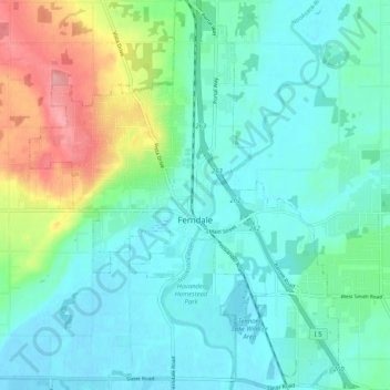
Name: Ferndale topographic map, elevation, terrain.

Location: Ferndale, Whatcom County, Washington, United States (48.81709 -122.63328 48.88463 -122.55058)

Average elevation: 29 m

Minimum elevation: -2 m

Maximum elevation: 120 m

Other topographic maps

Click on a map to view its topography, its elevation and its terrain.

Gear up for your next adventure:

🥾Mountaineering Boots - Supportive boots for climbing and high-altitude hiking
🥾Light Hiking Boots - Lightweight and comfortable boots for day hikes
🚲Heavy Duty Bike Lock - Secure your bike at the trailhead or during stops
🛶Waterproof Dry Bags - Keep electronics and clothes dry during river crossings
🧥Waterproof Hiking Jacket - Protect yourself from rain and wind while hiking

As an Amazon Associate, this site earns from qualifying purchases at no extra cost to you.