
Thank you for supporting this site ❤️
Make a donation
Make a donation
Gear up for your next adventure:
As an Amazon Associate, this site earns from qualifying purchases at no extra cost to you.
Andam topographic map
Click on the map to display elevation.
Thank you for supporting this site ❤️
Make a donation
Make a donation
Gear up for your next adventure:
As an Amazon Associate, this site earns from qualifying purchases at no extra cost to you.
About this map
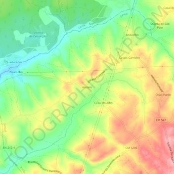
Name: Andam topographic map, elevation, terrain.
Location: Andam, Juncal, Porto de Mós, Leiria, 2460-282, Portugal (39.60458 -8.92513 39.64458 -8.88513)
Average elevation: 116 m
Minimum elevation: 53 m
Maximum elevation: 190 m
Thank you for supporting this site ❤️
Make a donation
Make a donation
Gear up for your next adventure:
As an Amazon Associate, this site earns from qualifying purchases at no extra cost to you.