Geolocate

Brampton East topographic map

Click on the map to display elevation.

About this map
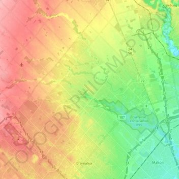
Name: Brampton East topographic map, elevation, terrain.

Location: Brampton East, Brampton, Caledon, Peel Region, Golden Horseshoe, Ontario, Canada (43.70829 -79.78190 43.84810 -79.63029)

Average elevation: 217 m

Minimum elevation: 155 m

Maximum elevation: 285 m

Peel Region trails, hiking, mountain biking, running and outdoor activities

Other topographic maps

Click on a map to view its topography, its elevation and its terrain.
Heart Lake

Canada > Ontario > Peel Region > Brampton

Average elevation: 254 m

Bonnie Braes Park

Canada > Ontario > Peel Region > Brampton

Average elevation: 203 m

Wildfield

Canada > Ontario > Peel Region > Brampton

Average elevation: 225 m

Coleraine

Canada > Ontario > Peel Region > Brampton

Average elevation: 210 m

Heart Lake

Canada > Ontario > Peel Region > Brampton

Average elevation: 254 m

Gear up for your next adventure:

🗺️Topographic Maps - Detailed maps to explore trails, mountains, and wilderness areas
🧴Insect Repellent - Protect yourself from bugs during outdoor adventures
🐕Hiking Dog Pack - Let your canine companion carry their own water and food
🧼Biodegradable Camp Soap - Environmentally friendly cleaning for gear and body
🌡️Emergency Mylar Blankets - Compact thermal protection for unexpected nights outdoors

As an Amazon Associate, this site earns from qualifying purchases at no extra cost to you.