
Make a donation
Gear up for your next adventure:
As an Amazon Associate, this site earns from qualifying purchases at no extra cost to you.
Rabigh topographic map
Click on the map to display elevation.
Make a donation
Gear up for your next adventure:
As an Amazon Associate, this site earns from qualifying purchases at no extra cost to you.
Rabigh
Rabigh (Arabic: رَابِغ, romanized: Rābigh) is a city and governorate in the Province of Makkah of the Kingdom of Saudi Arabia, situated on the coast of the Red Sea, around 208 km (129 miles) northwest of Mecca in the historic Hejazi region. The city had an estimated population of 180,352 in 2014 and is situated at an elevation of 13 m (43 ft) above sea level, close to the border with the Madinah Province. The city dates back to the era before the advent of Islam in the 7th century C.E., and up to the 17th century, was known as Al-Juhfah, or Al-Johfah (Arabic: ٱلْجُحْفَة, romanized: Al-Juḥfah).
Make a donation
Gear up for your next adventure:
As an Amazon Associate, this site earns from qualifying purchases at no extra cost to you.
About this map
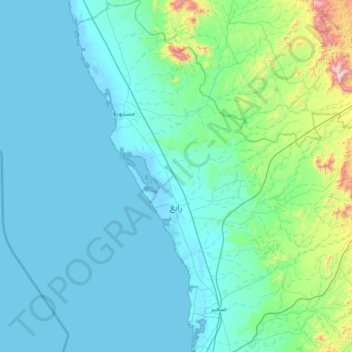
Name: Rabigh topographic map, elevation, terrain.
Location: Rabigh, Makkah Region, 23955, Saudi Arabia (22.30247 38.65977 23.49728 39.88517)
Average elevation: 145 m
Minimum elevation: -7 m
Maximum elevation: 1,730 m
Make a donation
Gear up for your next adventure:
As an Amazon Associate, this site earns from qualifying purchases at no extra cost to you.