
Make a donation
Gear up for your next adventure:
As an Amazon Associate, this site earns from qualifying purchases at no extra cost to you.
Manu topographic map
Click on the map to display elevation.
Make a donation
Gear up for your next adventure:
As an Amazon Associate, this site earns from qualifying purchases at no extra cost to you.
About this map
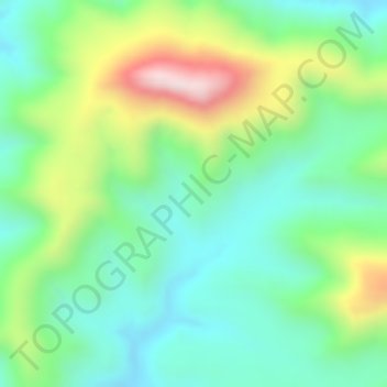
Name: Manu topographic map, elevation, terrain.
Location: Manu, North Gondar, Amhara Region, Ethiopia (12.44000 36.55666 12.46000 36.57666)
Average elevation: 1,057 m
Minimum elevation: 906 m
Maximum elevation: 1,338 m
Make a donation
Gear up for your next adventure:
As an Amazon Associate, this site earns from qualifying purchases at no extra cost to you.
Other topographic maps
Click on a map to view its topography, its elevation and its terrain.
Bahir Dar Special Zone
Bahir Dar is located at the exit of the Abbay from Lake Tana at an altitude of 1,820 metres (5,970 ft) above sea level. The city is located approximately 578 km north-northwest of Addis Ababa. The Lake Tana region is a UNESCO Biosphere Reserve since 2015.
Average elevation: 1,794 m