Geolocate

Shipley topographic map

Click on the map to display elevation.

About this map

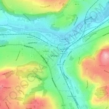
Name: Shipley topographic map, elevation, terrain.

Location: Shipley, Bradford, West Yorkshire, England, United Kingdom (53.82256 -1.81875 53.84245 -1.76197)

Average elevation: 121 m

Minimum elevation: 62 m

Maximum elevation: 225 m

Other topographic maps

Click on a map to view its topography, its elevation and its terrain.

High Utley

United Kingdom > England > Bradford > Keighley

Average elevation: 169 m

West Scholes

United Kingdom > England > Bradford > Thornton

Average elevation: 284 m

Gear up for your next adventure:

🔋Lithium AA Batteries - Long-lasting power that performs in extreme cold
🍽️Titanium Camping Spork - Ultralight and indestructible eating utensil
🧴Outdoor Sunscreen - High SPF protection for high-altitude UV exposure
🥾Lightweight Hiking Boots - Boots for comfort and mobility on long hikes
👟Trail Running Shoes - Agile footwear for fast-paced topographic exploration

As an Amazon Associate, this site earns from qualifying purchases at no extra cost to you.