
Make a donation
Gear up for your next adventure:
As an Amazon Associate, this site earns from qualifying purchases at no extra cost to you.
Pfitsch - Val di Vizze topographic map
Click on the map to display elevation.
Make a donation
Gear up for your next adventure:
As an Amazon Associate, this site earns from qualifying purchases at no extra cost to you.
About this map
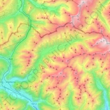
Name: Pfitsch - Val di Vizze topographic map, elevation, terrain.
Average elevation: 1,953 m
Minimum elevation: 866 m
Maximum elevation: 3,470 m
Make a donation
Gear up for your next adventure:
As an Amazon Associate, this site earns from qualifying purchases at no extra cost to you.
Other topographic maps
Click on a map to view its topography, its elevation and its terrain.
Eisacktal - Valle Isarco
Italy > Trentino-Alto Adige/Südtirol > South Tyrol
Average elevation: 1,487 m
Pens - Pennes
Italy > Trentino-Alto Adige/Südtirol > South Tyrol > Sarntal - Sarentino
Average elevation: 1,850 m
Sëlva - Wolkenstein - Selva
Italy > Trentino-Alto Adige/Südtirol > South Tyrol > Sëlva - Wolkenstein - Selva di Val Gardena
Average elevation: 1,828 m
Etsch - Adige
Italy > Trentino-Alto Adige/Südtirol > South Tyrol > Tarnell - Tarnello > Oberplatz
Average elevation: 1,075 m
Make a donation
Gear up for your next adventure:
As an Amazon Associate, this site earns from qualifying purchases at no extra cost to you.
Klettergarten Hohe Festung (Franzenfeste)
Italy > Trentino-Alto Adige/Südtirol > South Tyrol > Franzensfeste - Fortezza > Obersalcher
Average elevation: 1,048 m
Fleins - Lines
Italy > Trentino-Alto Adige/Südtirol > South Tyrol > Freienfeld - Campo di Trens > Mauls - Mules
Average elevation: 1,367 m
Viums - Fiumes
Italy > Trentino-Alto Adige/Südtirol > South Tyrol > Natz-Schabs - Naz-Sciaves
Average elevation: 847 m
Make a donation
Gear up for your next adventure:
As an Amazon Associate, this site earns from qualifying purchases at no extra cost to you.