Geolocate

Fort Worth topographic map

Click on the map to display elevation.

About this map

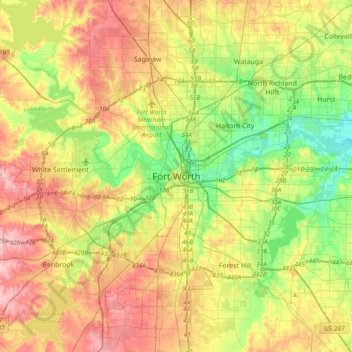
Name: Fort Worth topographic map, elevation, terrain.

Location: Fort Worth, Tarrant County, Texas, 76102, United States (32.59318 -97.49275 32.91318 -97.17275)

Average elevation: 202 m

Minimum elevation: 139 m

Maximum elevation: 279 m

Other topographic maps

Click on a map to view its topography, its elevation and its terrain.

Luther Lake

United States > Texas > Tarrant County > Fort Worth

Average elevation: 212 m

Gear up for your next adventure:

💧Filtered Water Bottle - Safe drinking water on the go
💧Reusable Water Bottle - Durable water bottles for hydration on trails
🧢Sun Hat - Wide-brim hat for sun protection
🧥Thermal Fleece Jacket - Versatile insulation for changing mountain temperatures
🧥Softshell Hiking Jacket - The perfect balance of wind protection and breathability

As an Amazon Associate, this site earns from qualifying purchases at no extra cost to you.