Geolocate

Usera topographic map

Click on the map to display elevation.

About this map

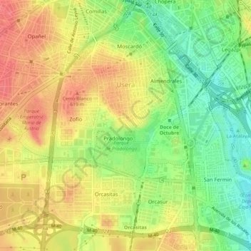
Name: Usera topographic map, elevation, terrain.

Location: Usera, Madrid, Community of Madrid, Spain (40.36144 -3.72089 40.39523 -3.68172)

Average elevation: 596 m

Minimum elevation: 560 m

Maximum elevation: 626 m

Gear up for your next adventure:

💡Compact LED Flashlight - Powerful and portable flashlight for outdoor use
🔋Emergency Crank Radio - Weather alerts and power without needing batteries
💧Filtered Water Bottle - Safe drinking water on the go
🧭Orienteering Kit - Tools for map reading and navigation in the wild
🧢Hiking Sun Hat - Wide-brimmed protection for exposed mountain ridges

As an Amazon Associate, this site earns from qualifying purchases at no extra cost to you.