
Tarvisio / Tarvis / Trbiž topographic map
Click on the map to display elevation.
About this map
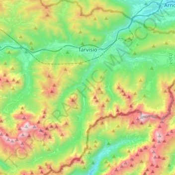
Name: Tarvisio / Tarvis / Trbiž topographic map, elevation, terrain.
Average elevation: 1,268 m
Minimum elevation: 547 m
Maximum elevation: 2,663 m
Other topographic maps
Click on a map to view its topography, its elevation and its terrain.
Santo Stefano
Italy > Friuli – Venezia Giulia > Udine / Udin / Videm > Chiaicis
Average elevation: 481 m
Gradischiutta / Radišče / Gradiscjute
Italy > Friuli – Venezia Giulia > Udine / Udin / Videm > Faedis / Fojda > Clap / Podrata
Average elevation: 540 m
Treppo Carnico / Trep di Cjargne
Italy > Friuli – Venezia Giulia > Udine / Udin / Videm > Treppo Ligosullo / Trep Liussûl
Average elevation: 974 m
Fusine in Valromana / Weißenfels / Bela Peč / Fusinis
Italy > Friuli – Venezia Giulia > Udine / Udin / Videm > Tarvisio / Tarvis / Trbiž
Average elevation: 967 m
Albana / Ibána / Albane
Italy > Friuli – Venezia Giulia > Udine / Udin / Videm > Prepotto / Prapotno / Prepot
Average elevation: 175 m
Monte Tamai
Italy > Friuli – Venezia Giulia > Udine / Udin / Videm > Ovaro / Davâr
Average elevation: 1,588 m
Scale / Skale
Italy > Friuli – Venezia Giulia > Udine / Udin / Videm > Drenchia
Average elevation: 610 m
Monte Lubia / Ljubija
Italy > Friuli – Venezia Giulia > Udine / Udin / Videm > Pulfero
Average elevation: 795 m
Montemaggiore / Brezje
Italy > Friuli – Venezia Giulia > Udine / Udin / Videm > Taipana
Average elevation: 817 m
Sandrine
Italy > Friuli – Venezia Giulia > Udine / Udin / Videm > Artegna / Dartigne > Borc dal Steli
Average elevation: 263 m