
Les Vastres topographic map
Click on the map to display elevation.
About this map
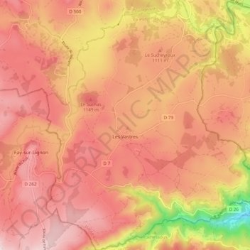
Name: Les Vastres topographic map, elevation, terrain.
Average elevation: 1,093 m
Minimum elevation: 757 m
Maximum elevation: 1,260 m
Other topographic maps
Click on a map to view its topography, its elevation and its terrain.
Pont de Chazeaux
France > Auvergne-Rhône-Alpes > Haute-Loire > Monistrol-sur-Loire
Average elevation: 731 m
Chambonnet
France > Auvergne-Rhône-Alpes > Haute-Loire > Saint-Préjet-d'Allier
Average elevation: 974 m
Cheneville
France > Auvergne-Rhône-Alpes > Haute-Loire > Varennes-Saint-Honorat
Average elevation: 1,055 m
Laniac
France > Auvergne-Rhône-Alpes > Haute-Loire > Siaugues-Sainte-Marie > Siaugues-Saint-Romain
Average elevation: 909 m