Geolocate

Ica topographic map

Click on the map to display elevation.

Ica

Ica has significant wine and pisco industries, annual fiestas, a museum and historic colonial churches. The climate is generally sunny and dry due to its elevation above coastal fog and mist. As of 2020, the Peruvian desert, around the Huacachina Oasis, has gotten significantly popular among tourists for sandboarding and sand buggy tours.

Wikipedia (CC-BY-SA 3.0)

About this map

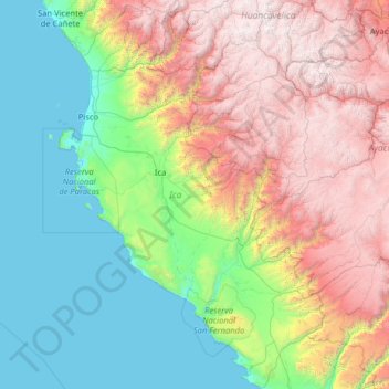
Name: Ica topographic map, elevation, terrain.

Location: Ica, Peru (-15.44378 -76.39836 -12.96493 -74.64624)

Average elevation: 1,624 m

Minimum elevation: 0 m

Maximum elevation: 5,179 m

Other topographic maps

Click on a map to view its topography, its elevation and its terrain.

Cienega

Peru > La Libertad > Patáz > Pataz

Average elevation: 3,092 m

Pumamarca

Peru > Apurímac > Tambobamba

Average elevation: 3,961 m

Cauca

Peru > Puno > Macari

Average elevation: 4,405 m

Mendoza

Peru > Ica

Average elevation: 127 m

Changa

Peru > Ancash

Average elevation: 3,402 m

Santa Fe

Peru > Loreto > Emilio San Martín

Average elevation: 103 m

Gear up for your next adventure:

🦯Trekking Poles - Reduced impact on joints for steep topographic climbs
Lightweight Camping Tent - Portable shelter optimized for Canadian backcountry camping
💡Compact LED Flashlight - Powerful and portable flashlight for outdoor use
🥾Mountain Hiking Boots - High-traction boots for rocky terrain
🔋Lithium AA Batteries - Long-lasting power that performs in extreme cold

As an Amazon Associate, this site earns from qualifying purchases at no extra cost to you.