Geolocate

Zittau topographic map

Click on the map to display elevation.

About this map

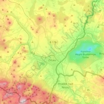
Name: Zittau topographic map, elevation, terrain.

Location: Zittau, Bertsdorf-Hörnitz, Görlitz, Saxony, Germany (50.81996 14.75506 50.99958 14.90693)

Average elevation: 323 m

Minimum elevation: 39 m

Maximum elevation: 727 m

Other topographic maps

Click on a map to view its topography, its elevation and its terrain.

Elster

Germany > Saxony > Görlitz > Zittau

Average elevation: 448 m

Mamut

Germany > Saxony > Görlitz > Jonsdorf

Average elevation: 519 m

Rohne - Rowno

Germany > Saxony > Görlitz

Average elevation: 127 m

Schlauroth

Germany > Saxony > Görlitz > Görlitz

Average elevation: 240 m

Bruder Klaus

Germany > Saxony > Görlitz > Jonsdorf

Average elevation: 523 m

Rosenbach

Germany > Saxony > Görlitz > Rosenbach > Rosenbach

Average elevation: 290 m

Gear up for your next adventure:

Backpacking Tent - Lightweight tent for long-distance hiking trips
🧦Hiking Socks - Moisture-wicking and comfortable socks for long hikes
🧢Beanie Hat - Keep your head warm in cold weather
🥾Hiking Shoes - Durable and comfortable shoes for trail hiking
🥾Mountaineering Boots - Supportive boots for climbing and high-altitude hiking

As an Amazon Associate, this site earns from qualifying purchases at no extra cost to you.