Geolocate

Deolali topographic map

Click on the map to display elevation.

About this map

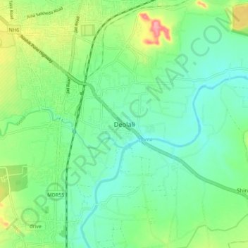
Name: Deolali topographic map, elevation, terrain.

Location: Deolali, Nashik, Maharashtra, 422400, India (19.89804 73.81671 19.97804 73.89671)

Average elevation: 565 m

Minimum elevation: 535 m

Maximum elevation: 635 m

Gear up for your next adventure:

🎒Backpack Rain Cover - External shield to keep your entire pack dry
🧴Outdoor Sunscreen - High SPF protection for high-altitude UV exposure
🧣Evaporative Cooling Towel - Beat the heat during intense summer climbs
🌬️Windproof Camp Stove - Efficient cooking even on exposed mountain peaks
Camping Groundsheet - Protect your tent from moisture and dirt

As an Amazon Associate, this site earns from qualifying purchases at no extra cost to you.