Geolocate

Hartenstein topographic map

Click on the map to display elevation.

About this map

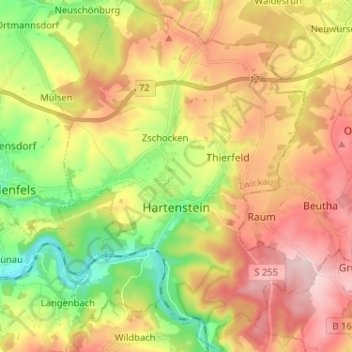
Name: Hartenstein topographic map, elevation, terrain.

Location: Hartenstein, Langenweißbach, Zwickau, Saxony, 08134, Germany (50.62835 12.62610 50.70991 12.71870)

Average elevation: 430 m

Minimum elevation: 292 m

Maximum elevation: 573 m

Gear up for your next adventure:

🥾Hiking Shorts - Breathable shorts suitable for summer hikes
🥾Durable Hiking Shoes - Long-lasting shoes for frequent hiking
🔪Outdoor Multitool - Versatile tool for repairs and food prep in the wild
Backpacking Tent - Lightweight tent for long-distance hiking trips
🧳Compression Sacks - Maximize space in your backpack by shrinking gear

As an Amazon Associate, this site earns from qualifying purchases at no extra cost to you.