
Make a donation
Gear up for your next adventure:
As an Amazon Associate, this site earns from qualifying purchases at no extra cost to you.
Lake Isabella topographic map
Click on the map to display elevation.
Make a donation
Gear up for your next adventure:
As an Amazon Associate, this site earns from qualifying purchases at no extra cost to you.
Lake Isabella
The town of Lake Isabella is located 35 miles (56 km) east-northeast of Bakersfield,[5] at an elevation of 2,513 feet (766 m).[4] The population was 3,466 at the 2010 census, up from 3,315 at the 2000 census.
Make a donation
Gear up for your next adventure:
As an Amazon Associate, this site earns from qualifying purchases at no extra cost to you.
About this map
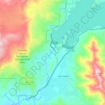
Name: Lake Isabella topographic map, elevation, terrain.
Location: Lake Isabella, Kern County, California, United States (35.59406 -118.53623 35.68126 -118.43083)
Average elevation: 994 m
Minimum elevation: 705 m
Maximum elevation: 1,634 m
Make a donation
Gear up for your next adventure:
As an Amazon Associate, this site earns from qualifying purchases at no extra cost to you.