Geolocate

Meramec Township topographic map

Click on the map to display elevation.

About this map

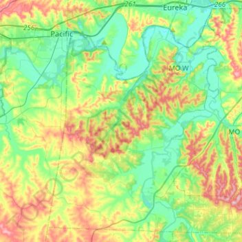
Name: Meramec Township topographic map, elevation, terrain.

Location: Meramec Township, Jefferson County, Missouri, United States (38.32523 -90.75555 38.50177 -90.51343)

Average elevation: 180 m

Minimum elevation: 124 m

Maximum elevation: 283 m

Other topographic maps

Click on a map to view its topography, its elevation and its terrain.

Local

United States > Missouri > Jefferson County

Average elevation: 176 m

High Ridge

United States > Missouri > Jefferson County

Average elevation: 246 m

Dittmer

United States > Missouri > Jefferson County

Average elevation: 193 m

Gear up for your next adventure:

🧴Bear Spray Holster - Quick-access carry for essential Canadian wilderness safety
🔦LED Flashlight - Powerful and long-lasting flashlight for camping and emergencies
🎒Hiking Daypack - Lightweight and durable backpacks for day trips and excursions
🥾Trekking Poles - Adjustable trekking poles to reduce knee stress and improve stability
👟Leg Gaiters - Keep debris, mud, and snow out of your boots

As an Amazon Associate, this site earns from qualifying purchases at no extra cost to you.