
Make a donation
Gear up for your next adventure:
As an Amazon Associate, this site earns from qualifying purchases at no extra cost to you.
Charlottetown topographic map
Click on the map to display elevation.
Make a donation
Gear up for your next adventure:
As an Amazon Associate, this site earns from qualifying purchases at no extra cost to you.
About this map
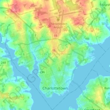
Name: Charlottetown topographic map, elevation, terrain.
Location: Charlottetown, Queens County, Prince Edward Island, Canada (46.21714 -63.19696 46.30657 -63.07340)
Average elevation: 19 m
Minimum elevation: -2 m
Maximum elevation: 65 m
Queens County trails, hiking, mountain biking, running and outdoor activities
Make a donation
Gear up for your next adventure:
As an Amazon Associate, this site earns from qualifying purchases at no extra cost to you.
Other topographic maps
Click on a map to view its topography, its elevation and its terrain.
French Village
Canada > Prince Edward Island > Queens County > Savage Harbour, Queen's County
Average elevation: 12 m