
Ban Khok topographic map
Interactive map
Click on the map to display elevation.
About this map
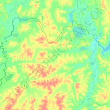
Name: Ban Khok topographic map, elevation, terrain.
Location: Ban Khok, Udon Thani Province, Thailand (17.62737 102.83969 17.94737 103.15969)
Average elevation: 173 m
Minimum elevation: 154 m
Maximum elevation: 206 m
Other topographic maps
Click on a map to view its topography, its elevation and its terrain.
Udon Thani
Thailand > Udon Thani Province
Udon Thani, Nong Samrong, Udon Thani Province, 41000, Thailand
Average elevation: 191 m
ภูฝอยลม
Thailand > Udon Thani Province > Udon Thani
ภูฝอยลม, Udon Thani, Udon Thani Province, Thailand
Average elevation: 545 m