
Make a donation
Gear up for your next adventure:
As an Amazon Associate, this site earns from qualifying purchases at no extra cost to you.
Chester Township topographic map
Click on the map to display elevation.
Make a donation
Gear up for your next adventure:
As an Amazon Associate, this site earns from qualifying purchases at no extra cost to you.
About this map
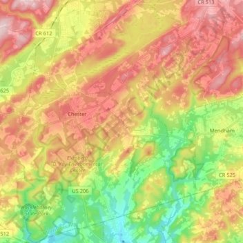
Name: Chester Township topographic map, elevation, terrain.
Location: Chester Township, Morris County, New Jersey, United States (40.71941 -74.74062 40.84112 -74.62372)
Average elevation: 207 m
Minimum elevation: 73 m
Maximum elevation: 338 m
Make a donation
Gear up for your next adventure:
As an Amazon Associate, this site earns from qualifying purchases at no extra cost to you.
Other topographic maps
Click on a map to view its topography, its elevation and its terrain.
Swinefield Bridge
United States > New Jersey > Morris County > East Hanover > Swinefield Bridge
Average elevation: 63 m
Butterworth Farms
United States > New Jersey > Morris County > Morris Township
Average elevation: 182 m