Geolocate

Köfering topographic map

Click on the map to display elevation.

About this map

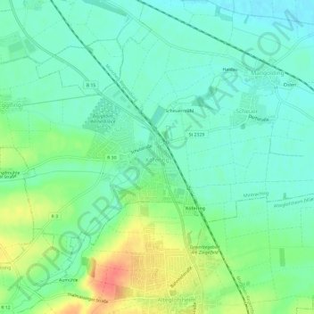
Name: Köfering topographic map, elevation, terrain.

Location: Köfering, Landkreis Regensburg, Bavaria, 93096, Germany (48.92532 12.15071 48.95024 12.21014)

Average elevation: 347 m

Minimum elevation: 330 m

Maximum elevation: 384 m

Other topographic maps

Click on a map to view its topography, its elevation and its terrain.

Langenerling

Germany > Bavaria > Landkreis Regensburg

Average elevation: 355 m

Eggmühl

Germany > Bavaria > Landkreis Regensburg

Average elevation: 382 m

Wahlsdorf

Germany > Bavaria > Landkreis Regensburg

Average elevation: 435 m

Gear up for your next adventure:

🥾Hiking Boots - Sturdy boots providing ankle support and traction on rugged trails
🚲Heavy Duty Bike Lock - Secure your bike at the trailhead or during stops
🔥Camping Stove - Portable stoves to cook outdoors with ease
🔭Outdoor Binoculars - Lightweight binoculars for birdwatching and hiking
🧶550 Survival Paracord - Versatile utility cord for emergency repairs and rigging

As an Amazon Associate, this site earns from qualifying purchases at no extra cost to you.