Geolocate

Sitka topographic map

Click on the map to display elevation.

About this map

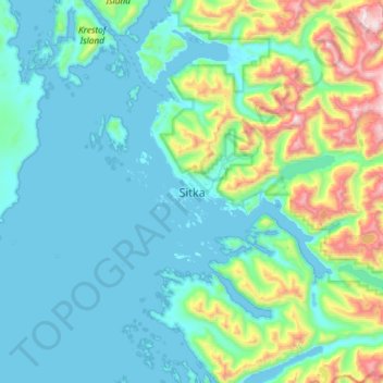
Name: Sitka topographic map, elevation, terrain.

Location: Sitka, Alaska, 99835, United States (56.89250 -135.49761 57.21250 -135.17761)

Average elevation: 240 m

Minimum elevation: -4 m

Maximum elevation: 1,513 m

Other topographic maps

Click on a map to view its topography, its elevation and its terrain.

Kruzof Island

United States > Alaska > Sitka

Average elevation: 88 m

Nameless Island

United States > Alaska > Sitka

Average elevation: 0 m

Road Island

United States > Alaska > Sitka

Average elevation: 28 m

Gear up for your next adventure:

🪑Insulated Seat Pad - Protect your seat from cold rocks and wet logs
🧥Waterproof Jacket - Lightweight rain jackets for hiking and outdoor activities
🧥Softshell Jacket - Windproof and breathable jacket for hiking
🧦Merino Wool Socks - Moisture-wicking comfort for long-distance hiking
🥾Mountain Trail Shoes - High-traction shoes for mountain trails

As an Amazon Associate, this site earns from qualifying purchases at no extra cost to you.