
Make a donation
Gear up for your next adventure:
As an Amazon Associate, this site earns from qualifying purchases at no extra cost to you.
Tingo Maria National Park topographic map
Click on the map to display elevation.
Make a donation
Gear up for your next adventure:
As an Amazon Associate, this site earns from qualifying purchases at no extra cost to you.
Tingo Maria National Park
Topography in the park is steep and mountainous, because the Bella Durmiente massif occupies almost of its entire extension. Elevations in the park are in the range of 650–1808 m; rocky walls of 300–500 m in height are common. Soils are calcareous, rocky and thin, and landslides due to natural causes or past attempts of agriculture do occur.
Make a donation
Gear up for your next adventure:
As an Amazon Associate, this site earns from qualifying purchases at no extra cost to you.
About this map
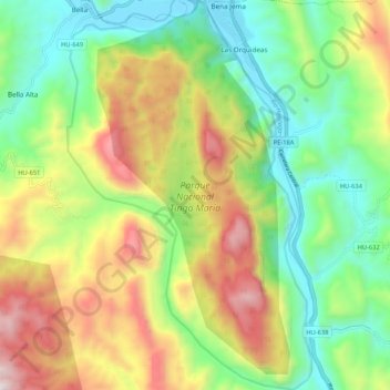
Name: Tingo Maria National Park topographic map, elevation, terrain.
Average elevation: 1,136 m
Minimum elevation: 645 m
Maximum elevation: 1,906 m
Make a donation
Gear up for your next adventure:
As an Amazon Associate, this site earns from qualifying purchases at no extra cost to you.