
Make a donation
Gear up for your next adventure:
As an Amazon Associate, this site earns from qualifying purchases at no extra cost to you.
Nature Park of Alvão topographic map
Click on the map to display elevation.
Make a donation
Gear up for your next adventure:
As an Amazon Associate, this site earns from qualifying purchases at no extra cost to you.
Nature Park of Alvão
The park has a temperate Atlantic climate with Mediterranean characteristics. The headlands of the Olo River are influenced by maritime air masses that rise over park's eastern boundary. This results in heavy precipitation during the winter months. These months are cold and rainy, with frequent snow showers in the high altitudes, while in the summer it is dry and warm. Most rain occurs in the colder months, while during the dry periods there is little rainfall, or concentrated in one month. The variation in slope allows for a diverse microclimate, with different vegetation between high and low altitudes. The combination of microclimatic conditions and rainfall has resulted in a lush landscape.
Make a donation
Gear up for your next adventure:
As an Amazon Associate, this site earns from qualifying purchases at no extra cost to you.
About this map
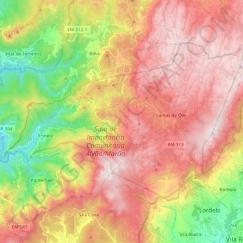
Name: Nature Park of Alvão topographic map, elevation, terrain.
Location: Nature Park of Alvão, Mondim de Basto, Vila Real, Portugal (41.32368 -7.92249 41.41253 -7.74115)
Average elevation: 830 m
Minimum elevation: 243 m
Maximum elevation: 1,325 m
Make a donation
Gear up for your next adventure:
As an Amazon Associate, this site earns from qualifying purchases at no extra cost to you.