
Thank you for supporting this site ❤️
Make a donation
Make a donation
Gear up for your next adventure:
As an Amazon Associate, this site earns from qualifying purchases at no extra cost to you.
Val-de-Ruz topographic map
Click on the map to display elevation.
Thank you for supporting this site ❤️
Make a donation
Make a donation
Gear up for your next adventure:
As an Amazon Associate, this site earns from qualifying purchases at no extra cost to you.
About this map
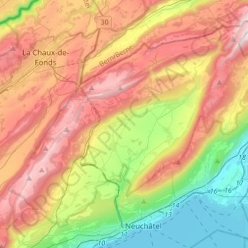
Name: Val-de-Ruz topographic map, elevation, terrain.
Location: Val-de-Ruz, Neuchâtel, Switzerland (46.98898 6.79541 47.12731 7.03996)
Average elevation: 923 m
Minimum elevation: 422 m
Maximum elevation: 1,510 m
Thank you for supporting this site ❤️
Make a donation
Make a donation
Gear up for your next adventure:
As an Amazon Associate, this site earns from qualifying purchases at no extra cost to you.