Geolocate

Ancud topographic map

Click on the map to display elevation.

About this map

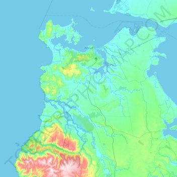
Name: Ancud topographic map, elevation, terrain.

Location: Ancud, Provincia de Chiloé, Los Lagos Region, Chile (-42.25431 -74.16061 -41.75748 -73.35335)

Average elevation: 80 m

Minimum elevation: -2 m

Maximum elevation: 811 m

Other topographic maps

Click on a map to view its topography, its elevation and its terrain.

Gear up for your next adventure:

🧥Waterproof Hiking Jacket - Protect yourself from rain and wind while hiking
🧤Rechargeable Heated Gloves - Extreme warmth for Canadian winter expeditions
🧦Thermal Socks - Warm socks for winter hiking or camping
🧢Outdoor Cap - Protective cap for sun and rain during hikes
🥾Approach Boots - Comfortable boots for hiking and climbing approaches

As an Amazon Associate, this site earns from qualifying purchases at no extra cost to you.