Geolocate

Borås topographic map

Click on the map to display elevation.

About this map

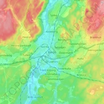
Name: Borås topographic map, elevation, terrain.

Location: Borås, Borås kommun, Västra Götaland County, 503 31, Sweden (57.68108 12.90074 57.76108 12.98074)

Average elevation: 192 m

Minimum elevation: 125 m

Maximum elevation: 314 m

Gear up for your next adventure:

🥫Freeze-Dried Meals - Lightweight, high-calorie nutrition for multi-day treks
🧥Ultralight Puffy Jacket - Maximum warmth that packs down to the size of an orange
🔭Compact Binoculars - Lightweight optics for scouting trails and wildlife
💡Portable Camping Lamp - Rechargeable lamp for campsite lighting
🧥Thermal Fleece Jacket - Versatile insulation for changing mountain temperatures

As an Amazon Associate, this site earns from qualifying purchases at no extra cost to you.