Geolocate

Ranrupt topographic map

Click on the map to display elevation.

About this map
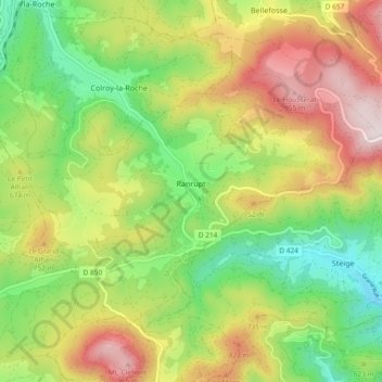
Name: Ranrupt topographic map, elevation, terrain.

Location: Ranrupt, Molsheim, Bas-Rhin, Grand Est, Metropolitan France, 67420, France (48.35022 7.15151 48.39536 7.24429)

Average elevation: 625 m

Minimum elevation: 332 m

Maximum elevation: 1,008 m

Other topographic maps

Click on a map to view its topography, its elevation and its terrain.
Strasbourg

France > Grand Est > Bas-Rhin > Strasbourg

Average elevation: 154 m

Ath

France > Grand Est > Bas-Rhin > Diemeringen

Average elevation: 255 m

Taubensee

France > Grand Est > Bas-Rhin > Niederbronn-les-Bains

Average elevation: 396 m

Le Haut des Monts

France > Grand Est > Bas-Rhin > Belmont

Average elevation: 849 m

Le Climont

France > Grand Est > Bas-Rhin > Urbeis

Average elevation: 621 m

Altenstadt

France > Grand Est > Bas-Rhin > Wissembourg

Average elevation: 172 m

Gear up for your next adventure:

🔋Emergency Crank Radio - Weather alerts and power without needing batteries
⛺Tent Footprint - Protect tent floor and increase durability
🦯Trekking Poles - Reduced impact on joints for steep topographic climbs
🧰Survival Kit - Essential gear for emergencies in the wilderness
⛺Bushcraft Tarp - Versatile emergency shelter or gear protection

As an Amazon Associate, this site earns from qualifying purchases at no extra cost to you.