Geolocate

Musho topographic map

Click on the map to display elevation.

About this map

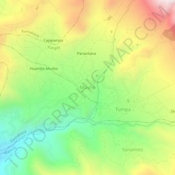
Name: Musho topographic map, elevation, terrain.

Location: Musho, Yungay, Province of Yungay, Ancash, Peru (-9.18973 -77.69253 -9.14973 -77.65253)

Average elevation: 3,083 m

Minimum elevation: 2,663 m

Maximum elevation: 3,621 m

Gear up for your next adventure:

Lightweight Camping Tent - Portable shelter optimized for Canadian backcountry camping
🔦LED Headlamp - Hands-free lighting for early morning starts or late finishes
🕯️Camping Lantern - Illuminates your entire campsite with high-efficiency LEDs
Family Camping Tent - Spacious tent suitable for family camping trips
🧢Hiking Hat - Sun-protective and breathable hats for long treks

As an Amazon Associate, this site earns from qualifying purchases at no extra cost to you.