Geolocate

Queenstown topographic map

Click on the map to display elevation.

About this map
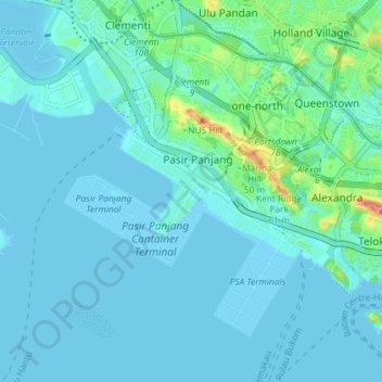
Name: Queenstown topographic map, elevation, terrain.

Location: Queenstown, Southwest, Singapore (1.24651 103.74558 1.31872 103.81660)

Average elevation: 10 m

Minimum elevation: -3 m

Maximum elevation: 78 m

Other topographic maps

Click on a map to view its topography, its elevation and its terrain.

Tanjong Pasir Laba

Singapore > Southwest

Average elevation: 4 m

Jurong Hill

Singapore > Southwest

Average elevation: 11 m

Bajau Hill

Singapore > Southwest > Singapore

Average elevation: 15 m

Gear up for your next adventure:

🥾Trail Running Boots - Durable shoes designed for trail running
🧢Sun Protection Cap - Breathable cap to protect from sun exposure
🧤Rechargeable Heated Gloves - Extreme warmth for Canadian winter expeditions
🥾Hiking Gaiters - Protect legs and shoes from mud, snow, and debris
🔥Camping Stove - Portable stoves to cook outdoors with ease

As an Amazon Associate, this site earns from qualifying purchases at no extra cost to you.