Geolocate

Honsfeld topographic map

Click on the map to display elevation.

About this map

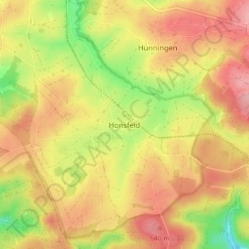
Name: Honsfeld topographic map, elevation, terrain.

Location: Honsfeld, Verviers, Liège, Wallonia, 4760, Belgium (50.36219 6.26312 50.40219 6.30312)

Average elevation: 604 m

Minimum elevation: 532 m

Maximum elevation: 657 m

Other topographic maps

Click on a map to view its topography, its elevation and its terrain.

Stoumont

Belgium > Liège > Verviers > Stoumont

Average elevation: 381 m

Trois-Ponts

Belgium > Liège > Verviers > Trois-Ponts

Average elevation: 411 m

Gear up for your next adventure:

🔋Solar Power Bank - Keep your GPS and devices charged during long outdoor trips
🐕Hiking Dog Pack - Let your canine companion carry their own water and food
🥾Mountain Hiking Shoes - Shoes with superior grip for mountainous terrain
🌡️Emergency Mylar Blankets - Compact thermal protection for unexpected nights outdoors
🧴Sunscreen SPF - Broad-spectrum sunscreen for outdoor activities

As an Amazon Associate, this site earns from qualifying purchases at no extra cost to you.