
Make a donation
Gear up for your next adventure:
As an Amazon Associate, this site earns from qualifying purchases at no extra cost to you.
Cantón de Paraíso topographic map
Click on the map to display elevation.
Make a donation
Gear up for your next adventure:
As an Amazon Associate, this site earns from qualifying purchases at no extra cost to you.
Cantón de Paraíso
Paraíso has an area of 476.99 km2 (184.17 sq mi) and a mean elevation of 1,171 m (3,842 ft).
Make a donation
Gear up for your next adventure:
As an Amazon Associate, this site earns from qualifying purchases at no extra cost to you.
About this map
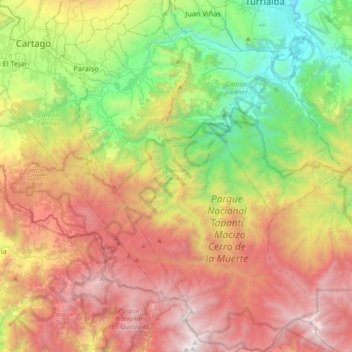
Name: Cantón de Paraíso topographic map, elevation, terrain.
Location: Cantón de Paraíso, Cartago Province, Costa Rica (9.55111 -83.89472 9.90788 -83.62702)
Average elevation: 1,821 m
Minimum elevation: 522 m
Maximum elevation: 3,472 m
Make a donation
Gear up for your next adventure:
As an Amazon Associate, this site earns from qualifying purchases at no extra cost to you.
Other topographic maps
Click on a map to view its topography, its elevation and its terrain.
Make a donation
Gear up for your next adventure:
As an Amazon Associate, this site earns from qualifying purchases at no extra cost to you.
Arenal Volcano
Costa Rica > Alajuela Province > Cantón San Carlos > La Fortuna
Average elevation: 1,014 m
Make a donation
Gear up for your next adventure:
As an Amazon Associate, this site earns from qualifying purchases at no extra cost to you.