Geolocate

Sumterville topographic map

Click on the map to display elevation.

About this map
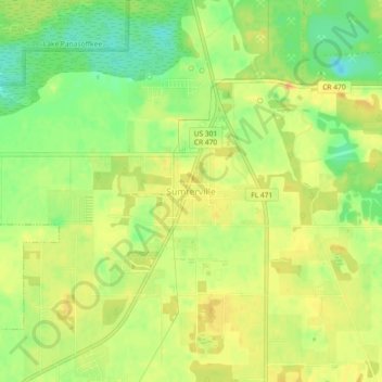
Name: Sumterville topographic map, elevation, terrain.

Location: Sumterville, Sumter County, Florida, 33585, United States (28.72499 -82.08342 28.76499 -82.04342)

Average elevation: 23 m

Minimum elevation: 2 m

Maximum elevation: 37 m

Other topographic maps

Click on a map to view its topography, its elevation and its terrain.

The Villages

United States > Florida > Sumter County

Average elevation: 24 m

Bushnell

United States > Florida > Sumter County

Average elevation: 22 m

Webster

United States > Florida > Sumter County

Average elevation: 28 m

Wildwood

United States > Florida > Sumter County

Average elevation: 23 m

The Villages

United States > Florida > Sumter County

Average elevation: 25 m

The Villages

United States > Florida > Sumter County

Average elevation: 24 m

The Villages

United States > Florida > Sumter County

Average elevation: 25 m

Wildwood

United States > Florida > Sumter County

Average elevation: 23 m

Webster

United States > Florida > Sumter County

Average elevation: 28 m

The Villages

United States > Florida > Sumter County

Average elevation: 25 m

Wildwood

United States > Florida > Sumter County

Average elevation: 23 m

Gear up for your next adventure:

💧Hydration Bladder - Hands-free hydration solution for long treks
🕶️Polarized Sunglasses - Protect your eyes with durable polarized lenses
🥾Mountain Hiking Shoes - Shoes with superior grip for mountainous terrain
⛺Camping Tent - Weather-resistant tents suitable for 2 to 6 people
☕Camping Coffee Maker - Brew fresh coffee anywhere on the topographic map

As an Amazon Associate, this site earns from qualifying purchases at no extra cost to you.