Geolocate

Mór topographic map

Click on the map to display elevation.

About this map

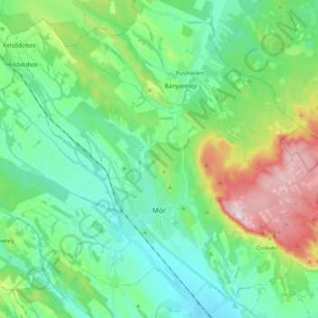
Name: Mór topographic map, elevation, terrain.

Location: Mór, Móri járás, Fejér, Transdanubia, Hungary (47.33478 18.09214 47.45199 18.28793)

Average elevation: 236 m

Minimum elevation: 144 m

Maximum elevation: 486 m

Other topographic maps

Click on a map to view its topography, its elevation and its terrain.

Sárpentele

Hungary > Fejér > Sárszentmihály > Sárpentele

Average elevation: 110 m

Gear up for your next adventure:

🧥Insulated Jacket - Keep warm in cold outdoor conditions
🔭Compact Monocular - One-handed bird watching and trail spotting
🥾Hiking Shorts - Breathable shorts suitable for summer hikes
👟Leg Gaiters - Keep debris, mud, and snow out of your boots
🥾Mountaineering Boots - Supportive boots for climbing and high-altitude hiking

As an Amazon Associate, this site earns from qualifying purchases at no extra cost to you.