Geolocate

Galapagar topographic map

Click on the map to display elevation.

About this map

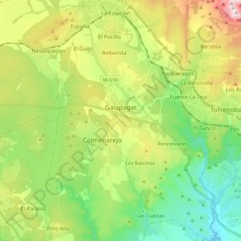
Name: Galapagar topographic map, elevation, terrain.

Location: Galapagar, Community of Madrid, Spain (40.50766 -4.04437 40.63300 -3.93790)

Average elevation: 849 m

Minimum elevation: 609 m

Maximum elevation: 1,276 m

Other topographic maps

Click on a map to view its topography, its elevation and its terrain.

Monte de El Pardo

Spain > Community of Madrid

Average elevation: 689 m

Gear up for your next adventure:

🛌Insulated Sleeping Pad - Critical thermal barrier between you and the cold ground
🥾Mountain Hiking Boots - High-traction boots for rocky terrain
🧣Evaporative Cooling Towel - Beat the heat during intense summer climbs
🥾Hiking Boots - Sturdy boots providing ankle support and traction on rugged trails
🥾Hiking Gaiters - Protect legs and shoes from mud, snow, and debris

As an Amazon Associate, this site earns from qualifying purchases at no extra cost to you.