
Espoo topographic map
Interactive map
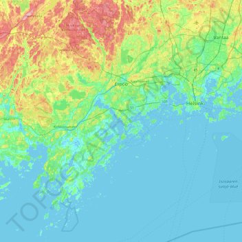
Click on the map to display elevation.
About this map
Name: Espoo topographic map, elevation, terrain.
Average elevation: 22 m
Minimum elevation: -3 m
Maximum elevation: 117 m
The minerals and structures of the rocky and hilly topography of Espoo were formed about 1880 to 1650 million years ago. Particularly the Weichselian glaciation has had an effect on the current environment - the continental ice sheet withdrew from what is now Espoo about 13 thousand years ago. The first areas to surface from underneath the sea were the high hills in northern Espoo, such as Mustankorvenkallio. The numerous smooth cliffs on the seashore and in the archipelago were caused by wear by the continental ice sheet; there are grooves on their surfaces, indicating the direction of the flow of the ice sheet. Icebergs split off from the ice sheet have transported glacial erratics, including those in Kunnarla, Soukka and Suomenoja.
Other topographic maps
Click on a map to view its topography, its elevation and its terrain.