
Adrianópolis topographic map
Click on the map to display elevation.
About this map
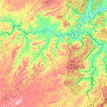
Name: Adrianópolis topographic map, elevation, terrain.
Average elevation: 616 m
Minimum elevation: 52 m
Maximum elevation: 1,478 m
Other topographic maps
Click on a map to view its topography, its elevation and its terrain.
Rio Branco do Sul
Brazil > Paraná > Região Metropolitana de Curitiba > Rio Branco do Sul > Rio Branco do Sul
Average elevation: 966 m
Praça Brasil
Brazil > Paraná > Região Metropolitana de Curitiba > Fazenda Rio Grande
Average elevation: 895 m