Geolocate

Riedenburg topographic map

Click on the map to display elevation.

About this map

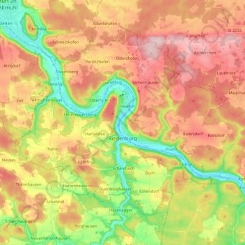
Name: Riedenburg topographic map, elevation, terrain.

Location: Riedenburg, Landkreis Kelheim, Bavaria, 93339, Germany (48.91803 11.59486 49.02163 11.80381)

Average elevation: 473 m

Minimum elevation: 345 m

Maximum elevation: 593 m

Other topographic maps

Click on a map to view its topography, its elevation and its terrain.

Buch

Germany > Bavaria > Landkreis Kelheim

Average elevation: 447 m

Offenstetten

Germany > Bavaria > Landkreis Kelheim

Average elevation: 385 m

Neuenkehrsdorf

Germany > Bavaria > Landkreis Kelheim > Riedenburg

Average elevation: 442 m

Paring

Germany > Bavaria > Landkreis Kelheim

Average elevation: 404 m

Gear up for your next adventure:

🔋Solar Power Bank - Keep your GPS and devices charged during long outdoor trips
🌬️Windproof Camp Stove - Efficient cooking even on exposed mountain peaks
👟Trail Running Shoes - Agile footwear for fast-paced topographic exploration
🛌Insulated Sleeping Pad - Critical thermal barrier between you and the cold ground
🧥Thermal Layer - Insulating layer for cold outdoor conditions

As an Amazon Associate, this site earns from qualifying purchases at no extra cost to you.