Geolocate

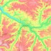
Y topographic map

Click on the map to display elevation.

About this map

Name: Y topographic map, elevation, terrain.

Location: Y, Péronne, Somme, Hauts-de-France, Metropolitan France, 80190, France (49.79028 2.97312 49.81407 3.00269)

Average elevation: 73 m

Minimum elevation: 50 m

Maximum elevation: 86 m

Other topographic maps

Click on a map to view its topography, its elevation and its terrain.

Petit-Camon

France > Hauts-de-France > Somme > Camon

Average elevation: 73 m

Amiens

France > Hauts-de-France > Somme > Amiens

Average elevation: 86 m

Larronville

France > Hauts-de-France > Somme > Rue

Average elevation: 8 m

Gear up for your next adventure:

🥾Approach Boots - Comfortable boots for hiking and climbing approaches
🧢Hiking Hat - Sun-protective and breathable hats for long treks
🥾Waterproof Trail Shoes - Shoes designed to handle wet terrain
🧥Waterproof Hiking Jacket - Protect yourself from rain and wind while hiking
🥾Mountain Trail Shoes - High-traction shoes for mountain trails

As an Amazon Associate, this site earns from qualifying purchases at no extra cost to you.