
Make a donation
Gear up for your next adventure:
As an Amazon Associate, this site earns from qualifying purchases at no extra cost to you.
Rappottenstein topographic map
Click on the map to display elevation.
Make a donation
Gear up for your next adventure:
As an Amazon Associate, this site earns from qualifying purchases at no extra cost to you.
Rappottenstein
Die Gemeinde besteht aus den Katastralgemeinden Dietharts, Gretschen, Großgundholz, Grünbach, Hausbach, Höhendorf, Kirchbach, Kleinnondorf, Lembach, Neustift, Oberrabenthan, Pehendorf, Pfaffendorf, Rappottenstein, Reichenbach, Riebeis, Ritterkamp, Roiten und Selbitz.
Make a donation
Gear up for your next adventure:
As an Amazon Associate, this site earns from qualifying purchases at no extra cost to you.
About this map
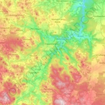
Name: Rappottenstein topographic map, elevation, terrain.
Average elevation: 739 m
Minimum elevation: 549 m
Maximum elevation: 927 m
Make a donation
Gear up for your next adventure:
As an Amazon Associate, this site earns from qualifying purchases at no extra cost to you.
Other topographic maps
Click on a map to view its topography, its elevation and its terrain.
Schönbach
Österreich > Niederösterreich > Bezirk Zwettl > Gemeinde Schönbach > Schönbach
Average elevation: 749 m
Gerlas
Österreich > Niederösterreich > Bezirk Zwettl > Gemeinde Zwettl-Niederösterreich
Average elevation: 600 m
Gerotten
Österreich > Niederösterreich > Bezirk Zwettl > Gemeinde Zwettl-Niederösterreich
Average elevation: 587 m
Make a donation
Gear up for your next adventure:
As an Amazon Associate, this site earns from qualifying purchases at no extra cost to you.
Mitterschlag
Österreich > Niederösterreich > Bezirk Zwettl > Langschlag > Mitterschlag
Average elevation: 834 m
Mitterreith
Österreich > Niederösterreich > Bezirk Zwettl > Gemeinde Zwettl-Niederösterreich > Mitterreith
Average elevation: 549 m
Make a donation
Gear up for your next adventure:
As an Amazon Associate, this site earns from qualifying purchases at no extra cost to you.
Kamles
Österreich > Niederösterreich > Bezirk Zwettl > Gemeinde Sallingberg > Kleinhaslau > Kamles
Average elevation: 729 m
Wolfsberg
Österreich > Niederösterreich > Bezirk Zwettl > Gemeinde Zwettl-Niederösterreich
Average elevation: 579 m
Make a donation
Gear up for your next adventure:
As an Amazon Associate, this site earns from qualifying purchases at no extra cost to you.
Rieggers
Österreich > Niederösterreich > Bezirk Zwettl > Zwettl-Niederösterreich
Average elevation: 616 m
Make a donation
Gear up for your next adventure:
As an Amazon Associate, this site earns from qualifying purchases at no extra cost to you.
Schloss Rosenau
Österreich > Niederösterreich > Bezirk Zwettl > Zwettl-Niederösterreich > Rosenau Schloss
Average elevation: 628 m
Make a donation
Gear up for your next adventure:
As an Amazon Associate, this site earns from qualifying purchases at no extra cost to you.