Geolocate

Ortega topographic map

Click on the map to display elevation.

About this map

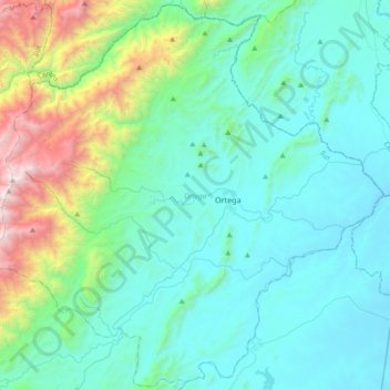
Name: Ortega topographic map, elevation, terrain.

Location: Ortega, Sur, Tolima, Colombia (3.75664 -75.44339 4.11947 -75.07206)

Average elevation: 755 m

Minimum elevation: 310 m

Maximum elevation: 2,860 m

Gear up for your next adventure:

🔪Outdoor Multitool - Versatile tool for repairs and food prep in the wild
🌡️Emergency Mylar Blankets - Compact thermal protection for unexpected nights outdoors
Camping Groundsheet - Protect your tent from moisture and dirt
Camping Essentials - All-in-one gear for a comfortable camping trip
🧴First Aid Kit - Essential first aid supplies for outdoor emergencies

As an Amazon Associate, this site earns from qualifying purchases at no extra cost to you.