Geolocate

Cordillera Real topographic map

Click on the map to display elevation.

About this map

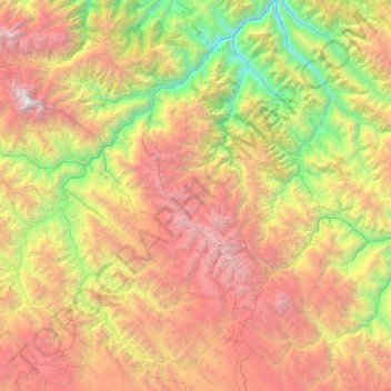
Name: Cordillera Real topographic map, elevation, terrain.

Location: Cordillera Real, Provincia Inquisivi, La Paz, Bolivia (-17.13653 -67.82890 -16.54538 -66.99772)

Average elevation: 3,317 m

Minimum elevation: 1,014 m

Maximum elevation: 6,410 m

Other topographic maps

Click on a map to view its topography, its elevation and its terrain.

Miguillas

Bolivia > La Paz > Provincia Inquisivi > Municipio Cajuata

Average elevation: 1,362 m

Gear up for your next adventure:

🥾Trail Hiking Shoes - Durable shoes designed for rugged trails
🧥Softshell Hiking Jacket - The perfect balance of wind protection and breathability
🔦LED Headtorch - Bright and durable light for night activities
🥾Trekking Boots - Durable boots for long-distance trekking
🏃Hydration Running Vest - Carry water and maps close to your body for speed

As an Amazon Associate, this site earns from qualifying purchases at no extra cost to you.