Geolocate

Baghdad topographic map

Click on the map to display elevation.

About this map
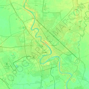
Name: Baghdad topographic map, elevation, terrain.

Location: Baghdad, Green Zone Municipality, Zawra District, Baghdad Governorate, Iraq (33.17976 44.18462 33.48683 44.57000)

Average elevation: 36 m

Minimum elevation: 26 m

Maximum elevation: 56 m

Other topographic maps

Click on a map to view its topography, its elevation and its terrain.

Tall Zuaitit

Iraq > Baghdad Governorate

Average elevation: 39 m

Sippar

Iraq > Baghdad Governorate > Al Yusufiyah

Average elevation: 37 m

Al saha

Iraq > Baghdad Governorate > Baghdad

Average elevation: 35 m

Ahwiz

Iraq > Baghdad Governorate

Average elevation: 40 m

An Nil

Iraq > Baghdad Governorate > Baghdad > An Nil

Average elevation: 37 m

Al Idrisi

Iraq > Baghdad Governorate > Baghdad > Al Idrisi

Average elevation: 37 m

Gear up for your next adventure:

🧊Portable Cooler - Keep food and drinks cold during outdoor adventures
🛶Waterproof Dry Bags - Keep electronics and clothes dry during river crossings
🪜Heavy Duty Carabiners - Multi-use clips for securing gear to your backpack
🪑Insulated Seat Pad - Protect your seat from cold rocks and wet logs
🕶️Polarized Sunglasses - Protect your eyes with durable polarized lenses

As an Amazon Associate, this site earns from qualifying purchases at no extra cost to you.