
Thank you for supporting this site ❤️
Make a donation
Make a donation
Gear up for your next adventure:
As an Amazon Associate, this site earns from qualifying purchases at no extra cost to you.
郭家 topographic map
Click on the map to display elevation.
Thank you for supporting this site ❤️
Make a donation
Make a donation
Gear up for your next adventure:
As an Amazon Associate, this site earns from qualifying purchases at no extra cost to you.
About this map
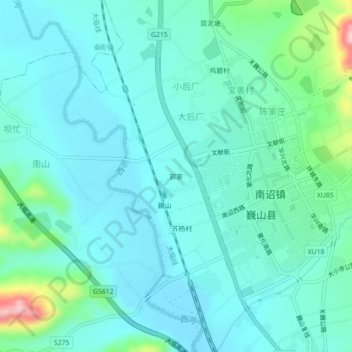
Name: 郭家 topographic map, elevation, terrain.
Location: 郭家, 大后厂, 南诏镇, 巍山彝族回族自治县, 大理白族自治州, 云南省, 中国 (25.21462 100.27462 25.25462 100.31462)
Average elevation: 1,728 m
Minimum elevation: 1,689 m
Maximum elevation: 1,913 m
Thank you for supporting this site ❤️
Make a donation
Make a donation
Gear up for your next adventure:
As an Amazon Associate, this site earns from qualifying purchases at no extra cost to you.