
Make a donation
Gear up for your next adventure:
As an Amazon Associate, this site earns from qualifying purchases at no extra cost to you.
Daporijo topographic map
Click on the map to display elevation.
Make a donation
Gear up for your next adventure:
As an Amazon Associate, this site earns from qualifying purchases at no extra cost to you.
Daporijo
Daporijo is located at an elevation of 600 m above sea level. It is located beside the river Subansiri, one of the principal rivers of Arunachal Pradesh, and a major tributary of the mighty Brahmaputra Daporijo valley is surrounded by Evergreen hills in three corners and Subansiri river in the other.
Make a donation
Gear up for your next adventure:
As an Amazon Associate, this site earns from qualifying purchases at no extra cost to you.
About this map
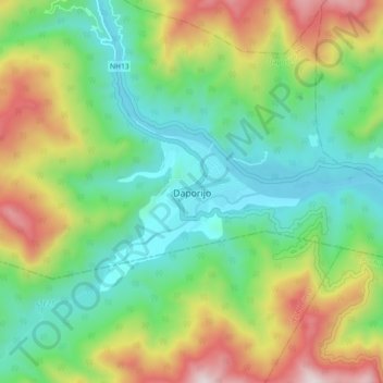
Name: Daporijo topographic map, elevation, terrain.
Average elevation: 541 m
Minimum elevation: 216 m
Maximum elevation: 1,171 m
Make a donation
Gear up for your next adventure:
As an Amazon Associate, this site earns from qualifying purchases at no extra cost to you.