Geolocate

Cape Clear topographic map

Click on the map to display elevation.

About this map

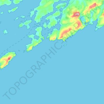
Name: Cape Clear topographic map, elevation, terrain.

Location: Cape Clear, West Cork, County Cork, Munster, P81 FY05, Ireland (51.38887 -9.60321 51.51625 -9.35321)

Average elevation: 10 m

Minimum elevation: -2 m

Maximum elevation: 190 m

Other topographic maps

Click on a map to view its topography, its elevation and its terrain.

Waterfall

Ireland > County Cork

Average elevation: 96 m

Gear up for your next adventure:

🦟Insect Repellent - Keep mosquitoes and black flies away in wooded areas
🧥Thermal Layer - Insulating layer for cold outdoor conditions
🥾Trekking Boots - Durable boots for long-distance trekking
📷Outdoor Action Camera - Capture high-elevation views and rugged adventures
🧦Merino Wool Socks - Moisture-wicking comfort for long-distance hiking

As an Amazon Associate, this site earns from qualifying purchases at no extra cost to you.