
Make a donation
Gear up for your next adventure:
As an Amazon Associate, this site earns from qualifying purchases at no extra cost to you.
Marseille topographic map
Click on the map to display elevation.
Make a donation
Gear up for your next adventure:
As an Amazon Associate, this site earns from qualifying purchases at no extra cost to you.
About this map
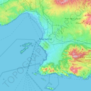
Name: Marseille topographic map, elevation, terrain.
Average elevation: 94 m
Minimum elevation: -5 m
Maximum elevation: 637 m
Make a donation
Gear up for your next adventure:
As an Amazon Associate, this site earns from qualifying purchases at no extra cost to you.
Other topographic maps
Click on a map to view its topography, its elevation and its terrain.
Aix-en-Provence
France > Provence-Alpes-Côte d'Azur > Bouches-du-Rhône > Aix-en-Provence
Average elevation: 279 m
Bassin du Vallon Dol
France > Provence-Alpes-Côte d'Azur > Bouches-du-Rhône > Marseille
Average elevation: 241 m
Mont Saint-Cyr
France > Provence-Alpes-Côte d'Azur > Bouches-du-Rhône > Marseille
Average elevation: 382 m
Make a donation
Gear up for your next adventure:
As an Amazon Associate, this site earns from qualifying purchases at no extra cost to you.
Barrage de Bimont
France > Provence-Alpes-Côte d'Azur > Bouches-du-Rhône > Saint-Marc-Jaumegarde
Average elevation: 354 m
Le Baguier
France > Provence-Alpes-Côte d'Azur > Bouches-du-Rhône > La Ciotat
Average elevation: 127 m
La Cride
France > Provence-Alpes-Côte d'Azur > Bouches-du-Rhône > Le Puy-Sainte-Réparade
Average elevation: 304 m
Make a donation
Gear up for your next adventure:
As an Amazon Associate, this site earns from qualifying purchases at no extra cost to you.