
Make a donation
Gear up for your next adventure:
As an Amazon Associate, this site earns from qualifying purchases at no extra cost to you.
Palestine topographic map
Click on the map to display elevation.
Make a donation
Gear up for your next adventure:
As an Amazon Associate, this site earns from qualifying purchases at no extra cost to you.
Palestine
About 40% of the content from the 2003 Space Shuttle Columbia disaster was recovered, seven astronauts were killed in the accident. Debris from Columbia was found in and outside Palestine and other East Texas towns. Palestine's NASA Columbia Scientific Balloon Facility (renamed in honor of the shuttle crew), has flown 1,700 high-altitude balloons for universities and research agencies.
Make a donation
Gear up for your next adventure:
As an Amazon Associate, this site earns from qualifying purchases at no extra cost to you.
About this map
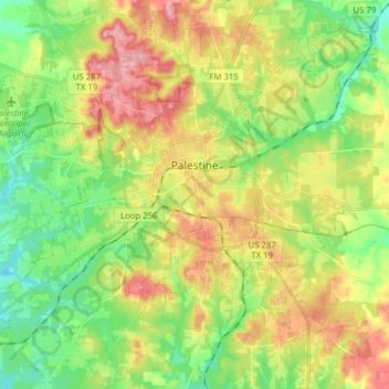
Name: Palestine topographic map, elevation, terrain.
Location: Palestine, Anderson County, Texas, United States (31.69527 -95.72426 31.80843 -95.56776)
Average elevation: 136 m
Minimum elevation: 85 m
Maximum elevation: 204 m
Make a donation
Gear up for your next adventure:
As an Amazon Associate, this site earns from qualifying purchases at no extra cost to you.
Other topographic maps
Click on a map to view its topography, its elevation and its terrain.
Make a donation
Gear up for your next adventure:
As an Amazon Associate, this site earns from qualifying purchases at no extra cost to you.