
Quincy topographic map
Click on the map to display elevation.
Quincy
Quincy has a Mediterranean climate (Köppen Csb) though its inland location and altitude makes it more continental and wetter than usual for this type, with very heavy snowfalls sometimes occurring in winter – the record being 133 inches (337.8 cm) in the very wet January 1916. Although summer days are hot and only 1.4 days per winter fail to top 32 °F (0 °C), nights can be very cold and frosts occur on 179 days per year and have been recorded even in July.
About this map
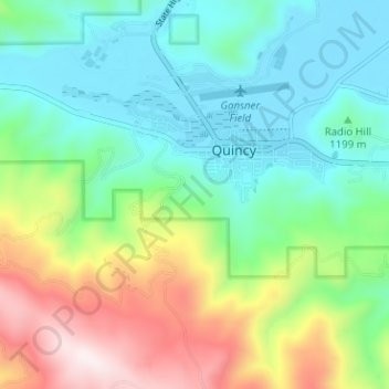
Name: Quincy topographic map, elevation, terrain.
Location: Quincy, Plumas County, California, 95971, United States (39.90682 -120.98896 39.95533 -120.93042)
Average elevation: 1,274 m
Minimum elevation: 1,035 m
Maximum elevation: 1,808 m
Other topographic maps
Click on a map to view its topography, its elevation and its terrain.