Geolocate

Campinas topographic map

Click on the map to display elevation.

About this map
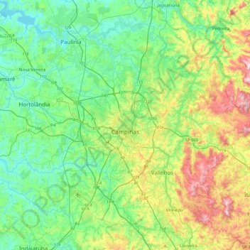
Name: Campinas topographic map, elevation, terrain.

Location: Campinas, Região Imediata de Campinas, Região Metropolitana de Campinas, Região Geográfica Intermediária de Campinas, São Paulo, Southeast Region, Brazil (-23.06122 -47.24630 -22.72905 -46.81528)

Average elevation: 666 m

Minimum elevation: 528 m

Maximum elevation: 1,017 m

Other topographic maps

Click on a map to view its topography, its elevation and its terrain.
Gear up for your next adventure:

🔋Lithium AA Batteries - Long-lasting power that performs in extreme cold
🥾Hiking Gaiters - Protect legs and shoes from mud, snow, and debris
🥾Approach Shoes - Shoes designed for climbing approaches and rugged trails
🥾Hiking Leggings - Comfortable leggings for outdoor activities
🥫Freeze-Dried Meals - Lightweight, high-calorie nutrition for multi-day treks

As an Amazon Associate, this site earns from qualifying purchases at no extra cost to you.